Saturday, July 23, 2011

Trout Lake, WA - Mt Adams, South Spur

When Megan broke her leg I promised that as soon as her leg was better to hike we would get out and do things before the summer was over and that if need be I would carry all her gear. Well she made me make good on that promise this weekend again...

We departed Portland around 8am on Saturday morning with the idea that we would get ourselves to Lunch Counter and then see how it goes. Somehow I just knew that Megan wouldn't be satisfied just half of the route - I'm getting to know this girl ;) Rolling into Trout Lake we stopped at the Ranger Station to pick up permits and get the latest schpeal from the rangers. We did find out that the road to Cold Springs was open all the way and that there was still so much snow on the mountain that the winter route was still very accessible so that was all good news. Megan ran into some of her Mazama friends heading in to do the Mazama Glacier route including the leader of her basics mountaineering class.
After squeezing the Camry into a tricky spot we got changed and shouldered our packs. Mine actually didn't feel too bad even though I had a ton of gear and pretty much everything for Megan and I to eat, sleep, cook and climb with for the weekend. (My new Mountain Hardware South Col pack is the best fitting pack I have owned to date. Although it isn't the lightest, tipping the scale at 3lb 14oz, it carries very well and can hold 70L.) I reminded myself about the pace of the Tortuga that Michael and I plodded on my first Rainier summit and chugged along.

At first many parties were passing us but as the day wore on Megan and I just kept our pace and soon enough we had caught and or passed many of them nearing Lunch Counter. That ended up giving us a wonderful choice of camp sites and we did choose a premier luxurious sandy spot for our home. As evening fell we cooked up a great Shepard's pie and tuna combination and followed that with a tri-berry crumble dessert and some Licorice tea. We bedded down early with the plan to rise around 6am and make our way to the summit.


Starting out on Trail 183

Leaving Tr183 and heading up the south spur

Mt St Helens, Crescent Glacier and my new pack


Marching up to Devil's Half Acre


Mt St Helens to the west


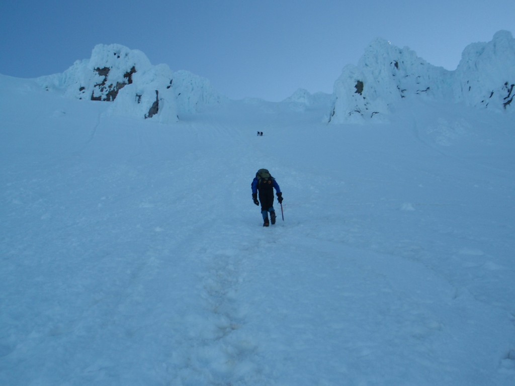
Megan almost to the Lunch Counter ~9000 ft.


The 'beach like' camp spot

The tent is set


Kitchen and storage is organized and water is getting melted in the JetBoil


Mountaineers favorite time...nap time


Sleeping beauty


The South Face - tomorrow's objective


Megan was the first one up and out of the tent in the morning; I was dragging as I didn't sleep so well through the night. With the stove going she fixed us some tea and oats for breakfast. A beautiful site was the shadow that Adams was casting to the west during sunrise. It reached out and almost touched Mt St.Helens and reminded me about the native's story. It goes something like this, Mt Adams and Mt Hood competed for St Helens favor. Mt Adams of course won out but in anger Mt Hood smacked him in the head and that is why Mt Adams has such a flat top.

Most parties had already made their way to the south slope and we could see them ascending like ants. However, like the day before Megan and I made great time up the slope and passed most of them on our way to the south summit. As we crested Pikers Peak around 11,000 ft. we had a quick snack and continued our way to the true summit. the clouds were moving very fast over 11,000' and the wind had really picked up. I had to put on a wind shell and a hat as the temperatures and wind chill were quite frosty. When we finally made the summit, I congratulated Megan on her new high point and told her I was honored once again to be there with her.


Adams shadow reaching out towards St Helens


What remains of Mt St Helens


Megan passing another tourist!

Moutaineeress approaches South Summit/Pikers Peak

Summit Partners and Megan's New High Point!

As for me this means I have been to the summit of every volcano in Washington state and only have 4 more to complete the PNW series.


Sunday, September 12, 2010

Sisters, OR - Middle Sister, North Ridge

It was another volcano that needed climbing and I needed a solo trip to rejuvenate my spirit. So it was, back to the wonderful Three Sisters Wilderness area. This time I would come in from the Obsidian trail head and camp high enough out of the limited area so as to not require a permit. I packed just enough food and gear as to make my load light and let me travel fast. I even left my boots at home and decided on trail runners for the ascent.

After a drive from Seattle shared with some concert goers who I let out at Eugene I turned towards Sisters and McKenzie Pass to reach my trail head around 1am. I slept in Westy until about 8am and then finished packing and hit the trail passing into the Obsidian area.

Obsidian Limited Entry Zone

After a few miles of hiking I reached a higher plateau which gave me a great view of my objective Middle Sister, 10,047ft. in height and fondly referred to as Hope. Her slopes were definitely snow covered but inviting nonetheless. Pushing along I eventually reached Obsidian Falls at 5 miles and a little further the Sister Spring where I could fill up with fresh mountain water. I consulted my map and found the re-entry to the upper plateau and a camping zone where I wouldn't need a permit.


Middle Sister, Hope


Obsidian Falls

At about ~7,200 feet I reached a nice spot which suited me fine for a position to climb the following day. I was close enough to water and it seemed quiet enough from the maddening crowds.


Home Sweet Home


Vibrant Lichen around my camp


West evening view


East evening view of Hope


A good nights rest prompted an earlier rise and the casual making of breakfast and coffee. Once fed I made a quick summit pack and began my trek up the Collier glacier and headed towards the North ridge. Higher on the snow pack I put on my crampons and make quick time on the glacier. I caught a party that was ahead of me for sometime as they rested and roped up at the bottom of the steeper ridge section. Glad I had my ice axe for the given snow sections, I eased my way up the ridge and onto the final stretch to the summit; 2:12 from my tent to the summit.


Lower moraines

Mt Washington, Three Finger Jack and Mt Jefferson l-r

First light on the Collier


Standard ascent gear: long underwear, runners and crampons


My trusty partner stayed with me the whole way


Rounding the corner to see my gal


Looking up the North Ridge route


Catching the other party along the ridge

Steeper section - doesn't look it however


On the summit looking north


Self portrait

Summit shot looking south


Chambers and Camp Lakes

After descending from the mountain and making my way back down the Collier I noticed a lone climber making their way up the glacier. As we met we began to chat and I discovered she was going to head up to the saddle between North and Middle. We talked about gear and conditions and the fact that we were both on solo trips. Megan was her name and we traded a couple of photo shots under a strangely wave shaped rock. Megan asked where I was camped and I told her up around the 7000+ foot level in a permit free zone. She mentioned that maybe she would try to find my camp and come by and say 'hi' later in the afternoon.


Happy climber


My new friend Megan

After returning to camp I crashed for an obligatory nap. When I woke I began going through my food supplies and realized that I hadn't packed enough for both a dinner and a breakfast the next day. I was quite hungry so I ate what little was left save a Gu shot and some chews. I decided that it would probably be best to pack up and head out since I was low on things to eat.

I made my way back down to the spring and stopped to scoop some water. There were a couple of people sitting on some rocks with a map out slightly up stream from me. As I put my pack on I heard someone call my name, it was Megan. She came over and asked me where I was going and that she was trying to figure out where I might have been camped. I told her the details of my food situation and she graciously offered to make me dinner saying she had plenty of food. Now how could I turn that down? As the evening fell Megan didn't think it was wise for me to hike out in the dark and suggested staying one more night and making my way out the next morning. It was great to have met Megan and perhaps our paths will cross again.


Life goes in crazy circles


Thursday, July 15, 2010

Squamish, BC - Calculus Crack etc.

A quick mid-week trip with James put us in Squamish to climb some moderates including Calculus Crack a sweet 5.9 moderate multi-pitch route on the Apron and another link-up in the Bullet Heads. The weather was great but just not enough time to stay and play.


Lower Apron - Calculus Crack 5.9

Tuesday, July 6, 2010

Government Camp, OR - Mt Hood, Palmer Glacier

"...yeah but I would prefer to be down before the semi-final World Cup between Uruguay and the Netherlands, will that work for you?" is how we set the schedule for this climb. Pope had a brief break from putting out fires and wanted to clip another hill in the Cascades that we have purposely ignored for the fact of crowds. However being the day after a holiday weekend we figured it might be quiet enough and would provide us with more training. I picked Chris up at his Mom's house Monday afternoon and we jollied our way down to Sandy where we stopped for some good eats at the Thai House and then on to Timberline Lodge. I was very impressed with the construction of the lodge and although its $220/nt price is a bit steep you definitely get a stay like no other.

After registration we packed up our gear and crawled into the Westy for about 3 hours of rest. Unfortunately those weren't to be had since the wind picked up and howled with 30mph gusts the whole evening. 12:45am came soon and we suited up and began our climb in about 15 minutes. It was quite warm but still windy and forecasts had the freezing level at around 13,000'. We could see the groomers working the ski hills and slowly made our way up to the top of the ski lifts fighting the wind the whole way. The gusts up higher could literally knock you over and we had to lean into the hill to keep from rolling backwards. We did haul a rope and pickets but never pulled them out - training weight I suppose. The fumaroles at the base of the Hogsback made this the stinkiest mountain I have ever climbed. A short steep section was fairly mundane and we met 2 others on their way off the summit here. We made the summit in about 5.5 hrs of climbing.

Once on top we enjoyed the views briefly, took some photos and set off on our way down. The summit was fairly narrow and not like the tops of the WA volcanoes which tend to have large broad summit plateaus. The top was the one place that it actually stopped blowing. The descent took about 3 more hours and found us back at the Westy and packing to go watch the game. Uruguay 2 Netherlands 3


Mt Hood South Side with the approximate route

Mt Hood sunrise shadow forming


Truck'in up around Crator Rock


Team C2 taking in a smelly Mt Hood at the base of the Hogsback


The last steep step to the Pearly Gates


Mr.Summit

Ms.Summit ?!?

Descent on the step - tracks around Crator Rock are visible below


On a side note this is my 14th individual Cascade Volcano mountain - some I have been on multiple times - with a goal to climb them all.